
Going Where the Water Suits my Clothes
- Dave

- Aug 17, 2025
- 10 min read
Updated: Aug 17, 2025
July 25-27, 2025
Jackson Harbor, Washington Island, WI to Garden, MI
Broadening that Farthest Horizon

Back in May, strong southerly winds thwarted an attempt to paddle through the Potowatomi Islands, north of Washington Island. It was actually Bridget who suggested we shoot for another weekend for it. And that took us to late July.

We both took off Friday to make the trip to Door County. We had many stops along the way, starting with a morning group run with friends in Nelsonville. Last minute supplies were purchased in Green Bay, and we settled into the drive up the Peninsula. Anther stop was made for our favorite Indian take-out at the Kinara Urban Eatery for dinner. Our ferry departure

was accidentally perfectly timed, as we basically drove straight onto the ferry and made it over to Washington Island for some trivia at the Point Grille. Before heading to our campsite for the evening, we took in a beautiful sunset from the tower at Mountain Park. This was just the ambiance we were looking for in a dining site.

I will say, though, that the view of the islands to the north and Michigan’s Garden Peninsula beyond were a bit daunting. That’s a lot of water to cover!
We arose before dawn the next morning to head straight for Jackson Harbor. This might be one of my favorite places-a protected bay with the promise of big water and vast horizons beyond.

Colorful skies and calm, clear water painted a beautiful picture as I prepared to paddle off into the sunrise and Bridget got ready for a bike ride.
We said our goodbyes and wished each other well as I took off, not to see each other until the next afternoon in Michigan’s Upper Peninsula. After Bridget finished her ride and returned to the mainland, she drove to DePere for an evening at her parents’ house, and the next morning made the 4-hour schlep all the way up the west side of Green Bay and over to Garden, where I hoped to be waiting. I must say that this was all actually Bridget’s idea. She wanted to see me make this leap from Wisconsin to Michigan after the first attempt was nipped in the bud. I’ll be indebted to her for some time after this one!

Endeavor felt great this morning as I left the harbor, the rocks and vegetation on the bottom cruising past my hull.

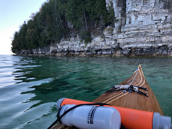
Water out on the Bay side of Rock Island was as near to glass as could be hoped. Paddling up the island shoreline, the turquoise water revealed the rocks below as I approached the wall of limestone at Rock Island’s northern point. This was as far as I had paddled before, my last time being here in late October, 2022.

A lone fishing boat being the only other vessel around, or sign of human life at all, for that matter. This is a veritable wilderness.
St Martin Isle lay before me on the horizon, its forests a bit shrouded in the haze of Canadian wildfire smoke. At about five miles, this would be my longest leap over open water, and conditions could not be better. Rather than feeling intimidated as I had the night before, I was exhilarated to be out here, with more water than land on the horizon. The last time I had been here was at the end of a season with paddling routes that stretched from Fremont on the Wolf River to this point. St. Martin was one island too many-it didn’t beckon me like other horizons had. This occasion was different. The time was right to make this jump and venture away from the mainland.

Such beauty, calm winds, a peaceful advance into waters I’ve never known before. The moment was to be relished, and I took off for St Martin at a strong cadence with a wide grin.
About half way there, I wondered why the hell I was in such a hurry to get this beautiful moment over with. I stopped to drink it in. To this point, I could go ashore to find civilization, shelter, a road, if nothing else. Sanctuary was always close at hand. This was different. I was out there. Wherever I went, I had to get myself out. The perfect conditions made this an extremely attractive prospect. It had the feel of playful exploration.
Funny how the second half of anything goes faster than the first. St Martin came into clearer view as Rock and Washington Isles faded behind me. I was now in Michigander territory. As I approached St Martin, seagulls sat upon the water. The attitude I projected upon them was an air of suspicion. As if they were eyeing me, saying, “What the hell are you doing here? This our territory.” Farther on, among the shoals, a pair of pelicans stood side by side upon a rock. They were even less tolerant of my presence than the gulls, taking flight to evade me.

In researching this route, I found there to be a couple old light houses, one on St. Martin and the other to the east on Poverty Island. I figured these relics would be worth checking out, so I stopped at the St Martin outpost. The buildings are still in tact, although the elements and nature are taking their toll. Early forest succession is happening on the grounds with sprawling aspen trees heaving the concrete sidewalk.

Man, the work that would go into just getting materials staged to build these structures. And now nature is taking over. I found a bit of relief in this sentiment. I saw a snake, then other, then another. There must be a healthy population of mice to keep these reptiles around. I later heard from a friend that mice had overrun Rock Island and they shut down some of the camping there because of it. Mold could be smelled from outside the lighthouse, and looking in the propped door, plaster and some framing members were starting to give way to moisture. I opted not to step inside. It must have been quite the existence for the people and families who would tend to these lights-about as solitary as it gets.
I walked back out to the steep shoreline and skipped a couple stones as tribute to my son who could spend days there doing just that. Three small islands sat evenly spaced, generally straight off shore, and Poverty Island was seen almost aligned with the center one. Much to the


chagrin of hundreds of cormorants that stood in the shoals, I headed straight for the north point of that middle island. A light wind popped out of the east as predicted, which was a refreshing reprise from the building heat. Winds would top out at about 8 mph, and temperatures rising into the mid 80s.
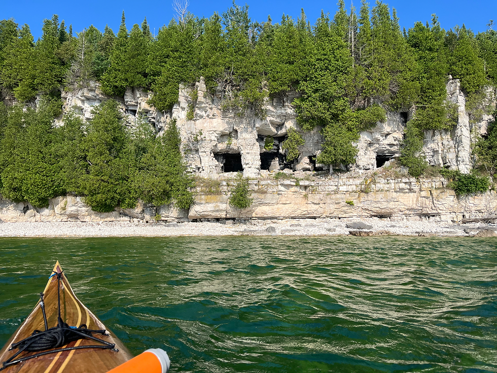
The old light house of Poverty Island could be seen from a distance as a square silhouette on the horizon of trees. An easy target, I made good time getting there, this marking about mile 14 on the day.
Exposed rock shoals popped above the surface just offshore from the old walls of this long-abandoned station.

Had I not spent so much time at the St Martin lighthouse, I’d have been all over this one for digging around and exploring. Less brush and more open than the last outpost, this area has an open beauty and ruggedness with the larger rock features and huge submerged boulders. Again, as in Lake Superior, they look like giant dinosaur eggs, just waiting to hatch under my hull. The exotic hue of the water lends a foreign feel to this area, but these mysterious waters are merely an extension of ones I’ve been at least familiar with most of my life. Suffice to say the remote beauty here is positively breathtaking.
Lingering for a bit, the scene was a lot to take in. The green water, storm-battered shoreline, ruins, wildlife, and the expansiveness of Upper Lake Michigan to the east. Still not fully grasping the essence of it all, I paddled up the south shoreline of Poverty Island and passed on up to Summer Island’s east shore. Rock Ledges and forest were the rule here, and as I rounded the north-eastern tip, private cottages could be seen through the trees.
A few hours in, I stopped for a breather at this 17 mile mark. Not having paddled much this summer, I was starting to feel the strain a bit. I pulled off to grab a bite, stretch the legs, and filter some water. I hung out in the sun, enjoying a bit of a lunch break.
“Umm, Hello…”
A woman peered out from the trees, startling me with her greeting.
“I just want you to know, you’re on private property.”
I apologized, explaining that I was just taking a breather and filtering some water.
“Uhhh, ok. Just so long as you’re not camping or anything….”
And so, I was back among society. Amazing what a difference just a few miles can make. This northern edge of Summer Island is perhaps 4 miles from the mainland of Upper Michigan’s Garden Peninsula, and the community of Fairport. Residents make it out to their cottages by boat. Just past the opposite end of the island, however, human presence seems far more the exception than the rule.
With a fresh stock of water I donned my skirt and headed for Little Summer Island, where my expected campsite was for the night. The whole east side of the island consists of broad shoals and fine rocks, and more algae than I’m used to.

The bay that sports a public shoreline was choked with an invasive phragmities grass and bull rushes. I retreated to the southern tip (also public) and weighed my options for camping. I found a spot in a grassy meadow that was flat enough for a tent, but something about this felt off. Uneven terrain, less than spectacular shoreline, and so many hours to sunset, all had me thinking to take my chances of finding a campsite on the mainland.

After mulling about for over an hour, I got back in the boat. Tired. Passing the lee of Summer Island, wind and waves were from the southeast off Lake Michigan. I thought I might paddle straight to Fairport, but cut my route short and ran downwind. I caught a swell or two for some easy riding, and generally had fun in the mild seas.
The limestone cliffs of the Niagra Escarpment continue from Door County on to the south and western shore of this, the Garden Peninsula. My route eventually joining and parallelling the shoreline, It struck me as what Door County might have looked like before tourists discovered it.
Lots of pristine forestland, clean water, and few boats. Most of the land here is held in private trust or conservancy. I passed Sac Bay County Park and rounded Burnt Bluff to enter Sand Bay. With a name like that there had to be a spot for me to bivouac for the night.
As I paddled along the shore, there generally seemed to be on this stretch a toe of somewhat flat terrain generally perched just above the shoreline, dark with cedars that choked out undergrowth. I could find a place to crash in there, if need be. Reading the terrain, though, the limestone cliff that backed up this strip of cedar lowland slanted gently back into the landscape and mature mixed hardwoods took over the more level shoreline. This seemed more the ticket.
At one point in the broad throat of the bay there was an opening in the surrounding woods. As I approached, I could see beach toys strewn about the shoreline. Evidently, people pull in here with their UTVs, as evidenced by the rutted path leading to the beach. The sand is great, but where there’s people there’s litter. I pulled ashore and considered cam

p. I pitched my tent in the middle of the path and picked up a bit of trash that I could carry with me the next day. Aside from it being the right thing to do, if anyone had anything to say about my being there I could show that I’m leaving the place better than when I arrived.
Then there was dinner to consider. The four burritos I’d prepared for the trip having been devoured (thank goodness they were finally gone!), I busted out the camp stove and some Indian curry packets with rice. Meals have gotten so easy it’s like cheating!
Wading out, I took an evening bath, hung my sweat-saturated gear to dry, and awaited sunset before crashing. My body hurt from so many hours in the boat, but again, I haven’t been hitting the water much. Just over 31 miles on the day, a good haul.

Next morning I awoke to a loud, intermittent squawking. What kind of bird was that? I rolled over and dozed a bit more. Finally exiting the tent, I dabbled around my campsite, taking in the morning air. The bird sounded again, and even though I was sure it was obscured in the thick brush, I looked up to see if I could find it. There, above my tent was a huge bald eagle. We looked each other in the eye, and I turned away first, not wanting to disturb this fella more than necessary. He took off shortly afterward, heading along the shore in search for breakfast. I made my own breakfast of oatmeal and got underway soon afterward.

I sliced the glassy waters to the other side of Sand bay under more bright skies to the historic Fayette Village site. Here, restored buildings from the
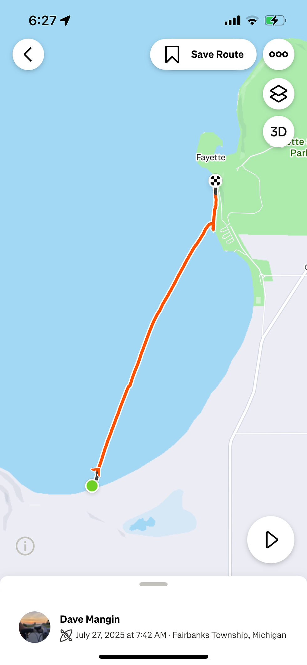
smelting operation that was running in the mid to late 1800’s stand as a beautiful sentiment to the past. It looks like it could have been a quaint existence in a beautiful place. But with the slag and waste dumped on the shore and in the lake, the small cottages that families dug into a hillside with farm animals tied in the lane, long hours by a blast furnace, and a “hotel” that welcomed guests and patrons paying by the hour, this place was more likely akin to providence turned into a man-made hell. Sure is a beautiful site now, though, with docking for recreational vessels to boot.


After a very brief tour, I took to the water again and headed up the coast, past inlets and lagoons of Big Bay de Noc, to the village of Garden. Sore and tired, I took out at a waterfront establishment known as The Dock.
I arrived at the opening hour, just in time for brunch. A salad and an Arnold Palmer hit the spot as I awaited Briget’s arrival.

She and Poe arrived early in the afternoon (locally an hour later, since this part of Michigan is on Eastern Time), but with enough daylight for us to hit up Fayette once more, coupled with ice cream! A sweet ending to a spectacular trip, but with a few postmarks.
Up till now, the waters I’d paddled from the Fox Valley kept getting more wild and pure. I had now crossed through the wilderness and out the other side, where people once again make their mark on the land and water, as we always do. There was a bit of a feeling of paradise lost in this, even though I knew the score going into this trek. I guess I didn’t expect that big, open water to have such a profound affect on me. So now, what of trekking further? Camping on the shoreline of the Great Lakes might be difficult do do, and I’m well beyond the notion of simple day trips from Stevens Point or Green Bay. I’ll now require a larger block of time to cover more significant ground at a stretch, or we’ll have to invest in a bigger boat. The jury is still out on this one.
Most of all which ever way this continues to progress, a HUGE thank you to Bridget, for continuing to insist that I go after my endeavors. I can only hope she feels the same level of support.

Comments